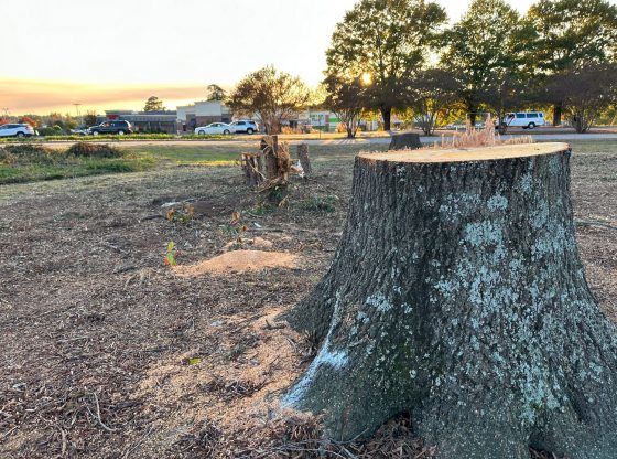
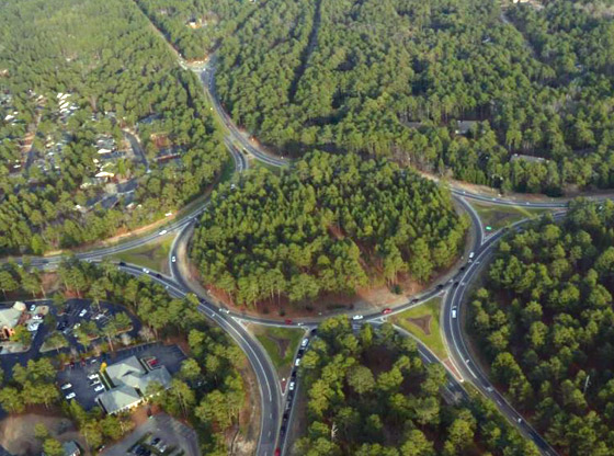
Commuters in and around Aberdeen and Southern Pines may have noticed significant changes in a few of the area’s highly traveled roads: N.C. 211, N.C. 5, U.S. Highway 1 and U.S. Highway 15-501. Trees have been removed, buildings have been bulldozed, and the dreaded orange barrels signaling roadwork have gone up in the evenings.
Aberdeen/Southern Pines “Superstreet”
Regarding the recent roadwork and tree removal along U.S. Highway 1 in Aberdeen, NCDOT Public Informations Officer Johnathan Rand told Sandhills Sentinel, “This is part of the superstreet (reduce conflict intersection) project. Currently we are clearing and grubbing and placing erosion control in preparation to move utilities prior to the contractor getting started on the roadway portion.”
According to the official project plans, changes will include the “addition of a raised median and limiting left turns in most areas.” Construction began earlier this year as crews began to remove vegetation and “obstructions” within the new right-of-way limits.
The project was set in motion in 2018, and NCDOT anticipates that all construction will be completed by fall of 2028. Per NCDOT’s website, the superstreet project is funded for $274 million.
Areas undergoing road construction include:
*U.S. 15-501 from U.S. 1 to Brucewood Road (U-5814):
A superstreet/reduced conflict intersection will be built on a 1.3-mile segment of U.S. 15-501 from U.S. 1 in Aberdeen to Brucewood Road in Southern Pines (view concept map).
*U.S. 1 (North Sandhills Boulevard) from Knight Street to Old U.S. 1 in Southern Pines. (U-5815B):
A superstreet/reduced conflict intersection will be built on a 2.6-mile segment from Knight Street in Aberdeen to Old U.S. 1 in Southern Pines (view concept map).
*N.C. 5 from U.S. 1 to the intersection of Trotter Drive/Blake Boulevard (U-5756):
A superstreet/reduced conflict intersection will be built on a 3.3-mile segment from U.S. 1 to Whitney Drive. A variable three to four-lane roadway will be built from Whitney Drive to Trotter Drive (view concept map).
Changes to N.C. 211
The second area in and around Aberdeen seeing significant changes—including the removal of trees and structures—is a long stretch of N.C. 211 spanning sections of Aberdeen, Ashley Heights, and Raeford.
“This is the R-5709A project where we are clearing and grubbing while the utilities are being relocated,” Rand explained. “This is in preparation of the R-5709C project for construction of the roadway from Raeford towards Ashley Heights.”
The official project plans detail that this corridor of N.C. 211 will be widened to a “four-lane road divided by a grass median from U.S. 15-501 in Aberdeen to West Palmer Street / Mockingbird Hill in Raeford, a distance of approximately 15.4 miles.”
A study conducted by NCDOT found that “in 2015, traffic volumes along N.C. 211 ranged from 4,200 vehicles per day (vpd) to 13,600 vpd. In 2040, traffic volumes are projected to increase more than 60 percent, ranging from 6,900 vpd to 22,300 vpd. By 2040, almost all segments of N.C. 211 in the study area will exceed the roadway’s capacity during peak travel time.”
NCDOT also reports that in a five-year period, 451 accidents occurred along this stretch of N.C. 211, with both the total crash rate and fatality rate exceeding the state average for comparable roads. The primary safety issues stem from traffic congestion and poor visibility.
The project will widen N.C. 211 from two to four lanes and improve dangerous curves, narrow shoulders, and visibility issues. The existing speed limit along N.C. 211 will not change with the project.
Feature photo: Corner of Highway 15-501 and U.S. 1 in Aberdeen, where trees have been cleared for the upcoming superstreet project.
~Article and photo by Sandhills Sentinel Assistant Editor Abegail Murphy. Abegail has been writing for Sandhills Sentinel since 2021.
Please click here to sign up for the free Sandhills Sentinel weekly e-newsletter.


