The National Transportation Safety Board (NTSB) released its preliminary report on a plane crash on the Outer Banks that resulted in five fatalities, two of whom were from Southern Pines.
Wright Brothers National Memorial released the names of the people on board the single-engine airplane when it crashed in September at First Flight Airport in Kill Devil Hills as Jason Campbell, 43, of Southern Pines; Kate Neely, 39, of Southern Pines; Shashwat Adhikari, 31, of Silver Spring, Maryland; Matthew Fassnacht, 44, of Marietta, Georgia; and a 6-year-old child. There were no survivors. The Army confirmed Campbell was stationed at Fort Liberty.
The NTSB released the following information.
On Sept. 28, the Cirrus SR-22 airplane was destroyed when it was involved in an accident near Kill Devil Hills. The private pilot and four passengers were fatally injured. The pilot departed from Moore County Airport on a multileg flight with stops at the Ocracoke Island Airport and Dare County Regional Airport before continuing to First Flight Airport in Kill Devil Hills.
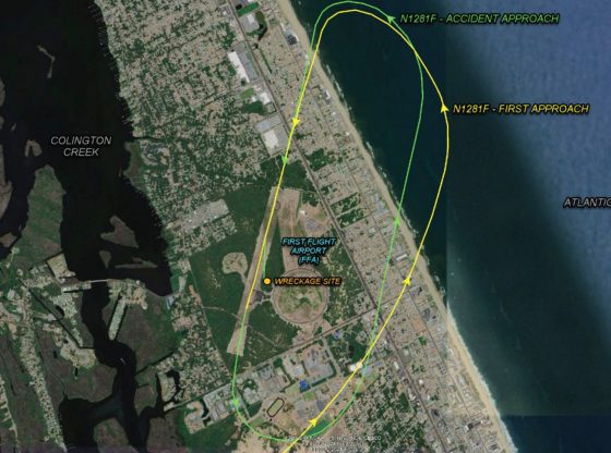
The accident flight departed from Dare County Regional Airport and was airborne for eight minutes prior to the accident. Preliminary Automatic Dependent Surveillance-Broadcast data provided by the Federal Aviation Administration (FFA) showed that after departing Dare County Regional Airport, the pilot flew to First Flight Airport and entered the left traffic pattern for runway 21.
The published airport traffic pattern for the runway was a right-hand pattern. The pilot descended and flew above the runway. He then climbed to traffic pattern altitude and rejoined the traffic pattern using left turns. The pilot approached the runway a second time and, according to witnesses, was high and fast during the approach. As the airplane passed the midway point of the runway, it made a steep left turn and impacted the top of 50-foot-tall trees. The airplane subsequently impacted additional trees before coming to rest 300 feet east of the runway in heavily wooded terrain, where a significant postimpact fire ensued.
A preliminary review of recorded audio communications on the common traffic advisory frequency did not reveal any distress calls from the pilot. The wind reported at FFA about the time of the accident was 170° at 6 knots, gusting to 14 knots. The airplane’s left wing impacted 50-foot-tall trees near the edge of the left side of the runway before the airplane contacted the ground approximately 135 feet from that initial contact point. The airplane came to rest in wooded terrain. A postimpact fire mostly consumed the airplane.
Feature photo: Figure 1- Preliminary ADS-B data showing the airplane’s flight track during the accident approach (green line) and the previous approach to the runway (yellow line).
Contributed information and photo from NTSB.


